Services

Add Value to Your Project.

Due Diligence.

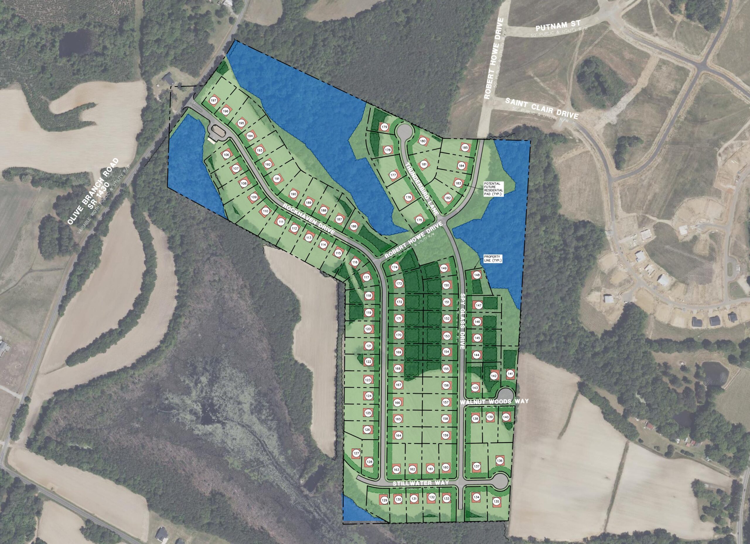
Take a proactive approach.

We research each site to determine the viability and feasibility of developing the land for its intended use. During this phase, we analyze the property’s:

  • Size, shape, location and topography
  • Easements and rights-of-way
  • Zoning and future land use
  • Uses and characteristics of adjacent properties
  • Wetlands and/or threatened species presence
  • Soil types and depth of water table
  • Availability of utilities
  • Storm water management and drainage criteria
  • Soil or groundwater contamination
  • Traffic and transportation characteristics
  • Estimated construction and land entitlement cost
  • Project schedule

Land Planning.

Bring your vision to life.

We can mold your desired project program into the context of the existing property and its surroundings, create a plan that maximizes the potential outcome, and guide you through the entitlement and approval processes.  Our services include:

  • Feasibility studies
  • Site and yield analysis
  • Conceptual land use planning
  • Highest and best use program development
  • Master planning
  • Comprehensive planning
  • Development ordinances
  • Entitlements and development approvals
  • Permitting and regulatory compliance
  • Rezoning and text amendment

Civil Engineering.

Build infrastructure that makes sense.

Our civil engineers’ experience, vision and design expertise can add value to your project. We can assist with:

  • Comprehensive site design services
  • Stormwater design and permitting
  • Sedimentation & erosion control design and permitting
  • Water distribution design and permitting
  • Sewer collection design and permitting
  • DOT driveway and encroachment permitting
  • Grading design and earthwork management
  • Roadway and parking lot design
  • Traffic control planning
  • Construction administration

Land Surveying.

Plot your future.

The Ballentine Survey team utilizes state-of-the-art equipment & technology to perform their complex and critically important work. Our services include:

  • Boundary and topographic surveys
  • ALTA/NSPS Land Title Surveys
  • Tree surveys
  • Wetland locations & mapping
  • Brownfield surveys
  • Terrestrial 3D laser scanning
  • Aerial LiDAR & Photogrammetry
  • Construction staking of all kinds
  • As-built surveys
  • Miscellaneous plats, exhibits and maps
  • Legal descriptions

Subsurface Utilities Engineering (SUE)

Mapping the Underground With Clarity and Confidence

Our Subsurface Utility Engineering (SUE) services help engineers, developers, and contractors locate and document underground utilities with accuracy and confidence. This not only prevents costly change orders and delays, but it also increases safety, reduces excavation risk and improves design accuracy. We work with a variety of clients in areas including residential and commercial developments, municipal infrastructure, institutional and campus projects and roadway improvements.

Our services include:

  • Level D – Records research
  • Level C – Surface feature survey
  • Level B – Geophysical designation
  • Level A – Precision daylighting
  • AutoCAD or Civil 3D drawings tied to project control
  • Utility attribute tables and metadata
  • PDF plan sheets and digital reports
  • Photos and notes for each exposure
  • Perfect integration support with your design team